Updated March 2025
Below are some of the questions and queries we have received which we aim to answer
We can’t say exactly how long it will be before development of the site is started as there are too many variables to discharge before that can happen. These include the Neighbourhood Plan consultation (consultation finished 14/03/25) and the subsequent referendum, and then our submitting a fresh planning application for the enlarged site. We anticipate submitting that fresh planning application later 2025, which means any construction work is unlikely to occur until late 2026 at the earliest.
Our neighbours expressed concern that lorries serving commercial enterprises further down Netherfield Lane might have difficulty in accessing the 90 degree turns. We have softened the access to Netherfield Lane and extended the “cul-de-sac” for existing residents in response to those concerns whilst also extending the green break “buffer”.
Yes, very likely, but hopefully only minor changes. This is an evolving project, and we have yet to employ a Landscape Architect to add further to the landscaping and ecological priorities. In addition, we are also exploring how to improve sustainability (renewables) to improve the running efficiency of the residential and commercial buildings. We will also continue to consult with our neighbours and the various stakeholders that have an interest in our scheme.
Yes, there are 60 homes on the current layout. We include the proposed gift of land to Baesh for 6 units as part of the overall numbers, and as part of the affordable housing ratio. We have reached a legal agreement with the Parish Council that there will be a covenant restricting the number of residential dwellings to a maximum of 60 if the site is included in the made Neighbourhood Plan.
No, because we need the land to be released from the green belt to enable us to build the new access road which in turn allows us to create the cul-de-sac.
We need the commercial elements to address the original planning appeal decision which directed us to look at a hybrid site to reduce the loss of local employment. The loss of local employment was an issue raised by some of our neighbours, and was taken on board by the Planning Inspector. With regards to the visual impact this will have, we are actively exploring buildings that do not look like conventional commercial premises. Our aim is to produce something that blends in better with the environment.
Because we responded to a call for sites to be considered for inclusion in the Neighbourhood Plan. It’s right and proper for us (and any other Landowner or Developer) to engage constructively in order to fully understand the local requirements, and how we might be able to assist.
In response to the existing East Herts Local Plan (adopted in 2018), the village is tasked with finding deliverable sites to create 94 new homes, an increase of 10% in the size of the village. The Neighbourhood Plan empowers local residents with a say towards how this is achieved, rather than by imposition by local government (East Herts District Council), or possibly at appeal. Those sites that are selected for the Neighbourhood Plan must be suitable, available and deliverable.
Much of the village falls under Flood Zone Risk 2 and 3 (medium and high). As part of the planning process, the LLFA (Local Lead Flood Authority) would object to building new homes where a flood risk exists. In the absence of suitable sites, the Neighbourhood Plan is then empowered to look at release of land from the green belt in order to fulfil the 94 homes quota required of the villages. The Neighbourhood Plan needs to release sufficient green belt land to cover a shortfall of 60 homes out of the quota of 94 homes.
The Draft Neighbourhood Plan has been produced. Recently the three Parish Councils (Great Amwell, St Margaret’s & Stanstead Abbotts) voted on whether to proceed with the Draft Plan (all three must agree to the proposal). The draft plan has been back to East Herts, and they have now launched a public consultation which ends on 14th March. After the comments raised during the consultation are considered by East Herts the Plan will go to an Examiner for inspection. Following this process there will be a local referendum. If the referendum votes in favour of it, it then becomes the adopted Neighbourhood Plan. View the Neighbourhood Plan consultation >
If the plan fails to materialise or the village referendum rejects it, then it falls to speculative / unplanned development to meet the shortfall in housing. This could well exceed the housing numbers that are currently the focus locally.
Housing needs change over time – with a largely upward trajectory. If housing delivery is to be through speculative / unplanned development (rather than the allocation of specific sites) then the number is unlikely to be limited to 94 new homes. The final number of homes could therefore be much higher, and further releases of land from the green belt would then also need to be considered.
You are probably referring to two sites, both of which are under the control of Catesby Estates Plc. The first of those locations is a 25-acre site situated within the green belt, and the second is an 85 acre site for the delivery of 490 homes also within the green belt. That’s a total of 110 acres and some 600 + homes that would connect the villages into Rye Park & Hoddesdon. The respective links are as follows:
https://www.catesbyestates.co.uk/uploads/files/St%20Margs%20Masterplan.pdf
https://www.catesbyestates.co.uk/uploads/files/Hoddesdon%20Masterplan%20Dec%202020.pdf
The adoption of the Neighbourhood Plan and inclusion of our site would limit additional green belt incursion. Our proposed site at Netherfield Lane is a total of approx 8 acres, of which 3.5 acres is brownfield (outdated industrial and offices) meaning that our site would only require the release of 4.5 acres of undeveloped land rather than a minimum of 25 acres or more at the other end of the village.
There is a housing shortage which needs to be addressed. The homes have to be built somewhere, and some encroachment into the green belt is inevitable. The green belt releases in Stanstead Abbotts are specifically mentioned in the East Herts District Council’s Local Plan to allow for the housing numbers to be met. Please refer to:
That’s incorrect. We are working with the Baesh Trust as to how we can assist them to provide further accommodation for local people (and/or people with local family/connections). The current line of thinking would be to gift land with planning permission for a small low rise courtyard development of 6 homes to be built that is neighbouring existing Almshouses. The Almshouses are listed buildings, and any courtyard development would have to be sympathetic and in keeping with the architectural and historic importance of the Almshouses.
You are correct, it would fit into a smaller site. We wish to avoid a high-density site, and don’t wish to have what would look like ‘shoeboxes’ stacked next to each other. We favour a landscape-led scheme that provides a lot of green open spaces, and which would be aesthetically pleasing when approached from the Roydon Road or viewed from Netherfield Lane. We appreciate that the residents of Netherfield Lane and the Roydon Road have open views from the front of their properties. As part of a landscape led- scheme, we are able to provide green buffers by way of mitigation to their altered views.
These are draft drawings that will evolve over time as we consult with our neighbours, the Parish Council and the various statutory authorities and planning departments so as to ensure that we conform to the relevant legislation and create a legacy benchmark-setting scheme. We aim to have a collaborative approach, and will happily listen to constructive criticism and engage with interested parties. The new access road would provide junction safety improvements with better visibility, and enable Netherfield Lane to become a cul-de-sac.
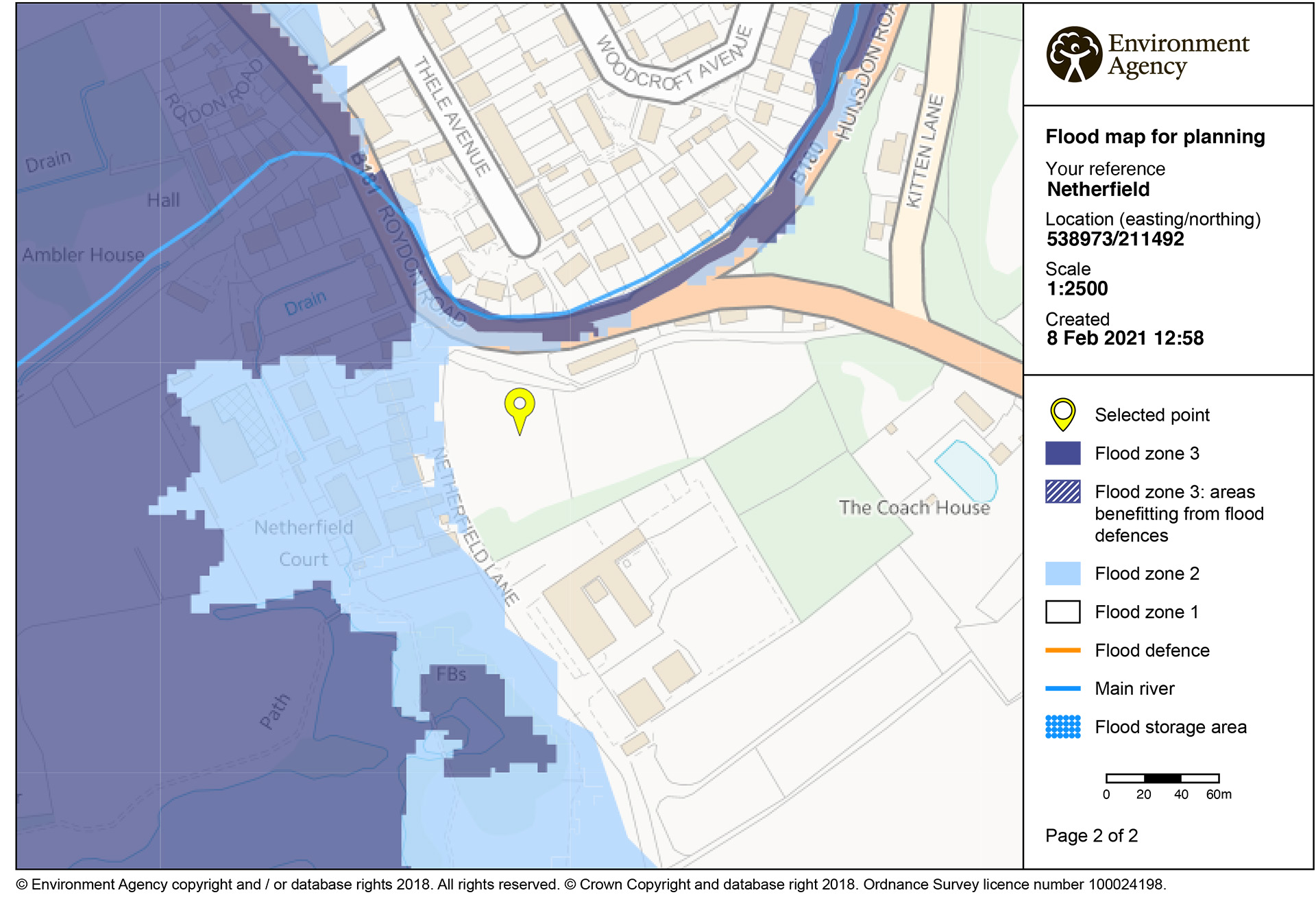
Our site falls within the Flood Risk Zone 1, which is the lowest flood zone risk (once in every 1,000 years). Please see the attached plan from the Environment Agency. Netherfield Lane itself falls within flood zone risk 1 and 2. Our site is on a slight incline that looks down onto Netherfield Lane. As part of the development of our site, it will be a pre-requisite of the LLFA that any flooding of Netherfield Lane is fully taken into account, and we would expect an improvement to the flooding of the Lane as part of the redevelopment.
The airfield which was operational from May 1918 to May 1919 from which two Bristol F2 aircraft operated. The runway which would have been a grass strip is believed to have operated from the other end of Netherfield Lane, towards the secured access to the A414. Further information can be found at:
We plan to erect a lasting and fitting memorial in memory of the servicemen.
So are we. David Webster, the founder of the lighting business formerly at Stanstead Abbotts, was a keen ecologist and conservationist. We continue to operate in a manner that we believe he would have approved of, and it is for that reason that we favour a Landscape-led scheme which would allow us to create a development that is ecologically sympathetic and facilitates meaningful ecological enhancement as part of the proposals.
We are striving to ensure that the development will meet higher standards than are required under current statute so as to minimise any carbon footprint. This is likely to include higher levels of insulation, EV charging points, solar cells, high efficiency heating as well as a large number of newtrees and habitats for wildlife.